


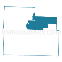
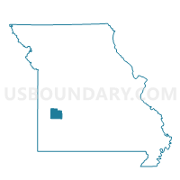
Washington Voting District, Cedar County, Missouri
About
Outline

Summary
| Unique Area Identifier | 607454 |
| Name | Washington Voting District |
| County | Cedar County |
| State | Missouri |
| Area (square miles) | 62.19 |
| Land Area (square miles) | 61.53 |
| Water Area (square miles) | 0.65 |
| % of Land Area | 98.95 |
| % of Water Area | 1.05 |
| Latitude of the Internal Point | 37.79551280 |
| Longtitude of the Internal Point | -93.76560640 |
Maps

Graphs
Select a template below for downloading or customizing gragh for Washington Voting District, Cedar County, Missouri


Neighbors
Neighoring Voting District (by Name) Neighboring Voting District on the Map
- Cedar Voting District, Cedar County, MO
- Collins Voting District, St. Clair County, MO
- Jefferson Voting District, Cedar County, MO
- Johnson Voting District, Polk County, MO
- North Linn Voting District, Cedar County, MO
- Washington Voting District, St. Clair County, MO
Top 10 Neighboring County Subdivision (by Population) Neighboring County Subdivision on the Map
- Linn township, Cedar County, MO (3,880)
- Johnson township, Polk County, MO (1,681)
- Washington township, Cedar County, MO (1,100)
- Jefferson township, Cedar County, MO (750)
- Collins township, St. Clair County, MO (667)
- Cedar township, Cedar County, MO (488)
- Washington township, St. Clair County, MO (287)
Top 10 Neighboring Unified School District (by Population) Neighboring Unified School District on the Map
- El Dorado Springs R-II School District, MO (8,193)
- Stockton R-I School District, MO (6,931)
- Humansville R-IV School District, MO (3,108)
- Weaubleau R-III School District, MO (2,616)
Top 10 Neighboring State Legislative District Lower Chamber (by Population) Neighboring State Legislative District Lower Chamber on the Map
Top 10 Neighboring State Legislative District Upper Chamber (by Population) Neighboring State Legislative District Upper Chamber on the Map
Top 10 Neighboring 111th Congressional District (by Population) Neighboring 111th Congressional District on the Map
Top 10 Neighboring Census Tract (by Population) Neighboring Census Tract on the Map
- Census Tract 9601, Polk County, MO (6,290)
- Census Tract 8701, Cedar County, MO (5,661)
- Census Tract 4802, St. Clair County, MO (2,952)